In any construction or excavation project, some of the greatest risks lie beneath the surface. Striking underground utilities – whether it’s gas pipes, electrical cables or buried storage tanks – can cause serious harm and injuries, project delays, environmental damage, and financial liabilities.
As a Project Manager at Severn Partnership specialising in utility surveys, I make sure these risks are mitigated for our clients using technologies such as Ground-Penetrating Radar (GPR) and on-site investigations, allowing for accurate utility detection and mapping.
In this article, I’ll explore the importance of a PAS 128 utility survey, the role they play in detecting buried utilities and how our services will protect both your team and the project from costly, dangerous accidents.
What are the dangers of hitting underground utilities?
Accidentally striking an underground utility during excavation can result in severe consequences:
- Gas pipes: Damaging a gas line can lead to leaks, which may lead to explosions, fire, or even deadly gas poisoning.
- Electrical and communication cables: Any contact with electrical lines can result in life-threatening electrocution and damage to the network causing power outages.
- Water or sewage pipes: Striking water or sewage lines can flood the site; cause contamination and delay further work for days or weeks.
- Buried storage tanks: If ruptured, buried storage tanks could leak hazardous substances into the environment.
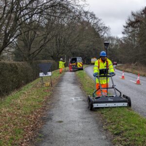
One of the more popular applications of Ground-Penetrating Radar (GPR) is utility mapping and detection, making it an essential tool in construction and excavation. Using GPR along with other techniques set out in PAS 128, we can locate and map underground utilities like cables, pipes and even buried storage tanks, giving our clients valuable insights before breaking ground.

Why are PAS 128 utility surveys critical before excavation?
A PAS 128 utility survey provides the groundwork for informed decisions, helping to avoid dangerous and costly mistakes.
- Standardisation and accuracy: A PAS 128 survey provides a comprehensive and standardised approach to utility detection, verification, and location. This ensures that the survey results are as accurate, reliable, and consistent as possible, reducing the risk of errors and omissions.
- Improved safety: By accurately identifying the location of underground utilities, PAS 128 surveys help prevent accidental strikes and reduces the risk of serious incidents.
- Cost efficiency: Accurate utility mapping helps avoid costly damage to existing infrastructure, saving significant expenses related to repairs, project delays, and potential legal fines.
- Risk management: PAS 128 surveys provide a full picture of the underground environment, enabling better risk assessment and management for more informed decisions.
- Improved project planning: Detailed and accurate utility information through a PAS 128 survey allows for better planning and design of excavation work, reduces the chance of any surprise obstacles and leading to fewer delays.
A well-executed PAS 128 survey provides a detailed and accurate map of the underground data that allows construction teams to work safely and efficiently. The non-invasive approach of the surveys means utilities can de detected without digging or disturbing the ground, saving time and minimising disruption.
When it comes to breaking ground, the risks associated with hitting underground utilities are too great to ignore. When a single mistake can have far-reaching consequences, ensuring the safety of your team and the success of your project needs to be a priority.
At Severn Partnership, we’re experts in using GPR and other technologies to map and detect underground utilities, helping our clients to be better informed.
You can download our PAS 128 Survey Guide below: