The Project
As part of the ambitious Transpennine Route Upgrade (TRU), Severn Partnership, in collaboration with Storm Geomatics, deployed Leica Pegasus:Two mobile mapping systems to carry out high-precision laser scanning across key sections of the network. Operating within tight night-time possession windows, our team delivered design-ready 3D data, enabling engineers and planners to work with greater speed, safety, and certainty.
Client Brief
The client required a complete and highly accurate reality model of the railway corridor, including stations, bridges, tracks, and surrounding infrastructure, to support the planning and delivery of the Transpennine Route Upgrade (TRU). The survey data needed to be precisely aligned and fully compatible with BIM workflows to enable design validation, clash detection, and collaborative project delivery. All scanning was to be carried out within restricted night-time possession windows to avoid disruption to the live railway, with a strong emphasis on safety, speed, and minimal return visits.
Survey Scope
The survey scope focused on delivering rapid, accurate data acquisition across several key sites. Using The Leica Pegasus:Two Ultimate, Severn captured high-precision datasets to support a federated 3D model for the design team. The scope also prioritised safety and operational efficiency by reducing time spent on or near the tracks.
Challenges
The team faced several operational constraints typical of live rail and water-adjacent infrastructure projects, including:
- Working within a safety-critical environment requiring full compliance with rail and water safety protocols
- Surveying Victorian-era structures with limited access due to surrounding terrain, viaduct height, and river conditions
- Capturing a high volume of survey-grade data in limited possession windows and challenging weather conditions
- Acquiring sufficient structural detail from difficult vantage points, where traditional static scanning was no longer viable

Solutions
To overcome these complex challenges, Severn Partnership implemented a streamlined, technology-led workflow in collaboration with Storm Geomatics:
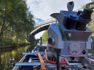
- Mounted the Leica Pegasus:Two mobile mapping system to a watercraft, enabling proximity scanning of bridges and viaducts from the River Calder and other locations that were previously inaccessible
- Used Leica Pegasus:Manager’s Mission Planning and integrated processing tools to optimise both scan acquisition and data handling, from selecting the best time and accuracy parameters before going on site, to automatically combining GNSS, IMU, camera, and LiDAR data into a single, georeferenced dataset
- This integrated workflow enabled the rapid capture of mass data volumes in a single day, compared to traditional methods that could take weeks, while also reducing on-site exposure and improving health and safety
Deliverables
- Fully registered point cloud data (E57 format) with linked panoramic imagery
- BIM-compatible outputs, including 3D models of bridges, viaducts, and surrounding terrain
- Georeferenced datasets combining GNSS, IMU, LiDAR, and imagery into a single, aligned deliverable
- Exportable file formats tailored for direct integration into the client’s CAD and design platforms
Project Outcome
The survey enabled the accurate 3D modelling of key railway infrastructure across the Transpennine Route Upgrade, providing the client design and project team with a reliable foundation to progress their plans. Early clash detection, improved coordination, and a reduction in on-site activity led to both time and cost savings. By using advanced mobile mapping technologies and streamlined workflows, Severn Partnership significantly reduced traditional survey timeframes while ensuring all deliverables were precisely aligned, fully compatible with BIM standards, and ready for immediate integration into the client’s design process.
The success of this project has also positioned Severn Partnership for continued involvement in future TRU phases, further strengthening our commitment to modernising the UK’s rail network through innovation-led surveying.
Testimonial
“Having a reliable and precise digital record of the route has been a game-changer for our planning process. By leveraging mobile mapping and water-based survey methods, we delivered accurate results quickly and safely, even in some of the most logistically complex areas of the upgrade programme. This approach not only accelerated delivery but also reduced the need for repeated site visits, improving efficiency and minimising disruption across the project.”
Luke Blakemore, Project Manager MCInstCES
Environmental & Social Impact
Severn Partnership’s use of mobile mapping technology significantly reduced the time surveyors needed to spend on site, leading to fewer shifts, less travel, and a lower environmental footprint. By delivering accurate, design-ready data in fewer visits, the project helped reduce disruption to both rail operations and nearby communities. Supporting the modernisation of this key transport corridor also contributes to a more efficient and sustainable rail network, aligned with long-term goals for greener infrastructure and enhanced regional connectivity across the North of England.
Interested in how Mobile Mapping could support your next project?
Get in touch with our Mobile Mapping Project Manager, Luke Blakemore or connect with him on LinkedIn to start the conversation.