Heritage Lottery Fund Project – Roundhouse Summary:
Heritage Lottery Fund project, commissioning ‘reality capture’ using high definition 3D laser scanning as the most efficient way to document a Grade II* listed Canals Trust building.
Project Overview:
Originally constructed as a mineral and coal wharf, the Roundhouse is strategically placed in the center of Birmingham to take advantage of the Canal to the South, and former London & Northern Western Railway to the North. The canal network comprises of 35 miles of water-ways which formed the commercial backbone of Victorian Birmingham; allowing coal and raw materials to be shipped into the city’s thriving factories and exporting manufactured goods across the country. The Roundhouse stored it’s materials in the large brick barrel-vaulted chambers facing the canal. The central largest arch allowed horse & carriage access from the rear to the secure internal courtyard, where there remains evidence of stables for up to 200 horses. Much of these features remain untouched, making the Roundhouse a leading example of Birmingham’s rich industrial heritage, represented by it’s grade II* listing.
Now vacant, the building is owned by the River Canal Trust, who alongside the National Trust hope to restore the building back to it’s former glory after being placed on the Heritage ‘at risk’ register. The Heritage Lottery Fund has awarded an initial £225,000 development grant which will be used to work up these plans into a larger £2.9 million scheme that will see the full restoration of this unusual building. The building will be transformed into a base from which to explore the canal network including a cycle hire and repair workshop.
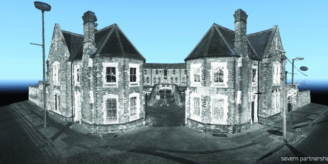
In order for the project to move forward, The Severn Partnership were commissioned by the Canal River Trust to undertake a 3D Laser Scan of the building to ascertain the extent of the bowing walls and structural issues. In this case given the extent of the movement within the building 3D Laser Scanning is the only methodology which allows you to make an accurate prognosis. Over 150 static scans were recorded throughout the site to gain full interior and exterior coverage. Inside, utilizing an extended tripod which reaches 3.5 meters, we were able to scan above ceilings through hatches to capture the roof structure. This information was critical to determine the magnitude of the spreading.
Instruments and software:
- Trimble Total Stations were used to install and observe an accurate closed traverse externally around the building and internally over each level.
- Our surveyors completed the scanning using both a Leica P20 and Z&F Imager 5010C.
- Leica Cyclone 9.1 registration software allows you to combine individual scans into a single unified cloud using visual alignment tools.
- AutoCAD 2016 for the drafting.
Deliverables:
- 28 Sections strategically placed to allow for an in-depth analysis.
- Software packages such as Autodesk Revit do not offer the user much flexibility when recreating complex 3D geometry. In this instance, where the tolerance needed to be as low as possible, a 2D output is far more suited.
- A single unified Point Cloud.
- TruView.
- Our surveyors completed the site work over three shifts, followed by 3 days office processing and 7 days drafting.