Overview
When redevelopment takes place just metres from active, operational buildings, precision is essential. Severn Partnership was commissioned to deliver a monitoring survey to safeguard neighbouring structures during nearby construction works, ensuring reliable data, minimal disruption, and complete confidence in structural stability.
Client Brief
The client required a two-phase monitoring survey to track any structural movement in existing buildings adjacent to the redevelopment site. The monitoring data would act as a reliable reference point for assessing construction impact, informing future maintenance plans, and reducing potential legal or safety risks.

Survey Scope
Severn Partnership completed two scan-based monitoring surveys, spaced six months apart.
A closed-loop control network was established and validated during each survey phase, providing a consistent foundation for accurate alignment. Each visit included full re-observation of control points to confirm positional stability and maintain comparability between datasets.
Using the Leica RTC360 terrestrial laser scanner, the team captured over 600 million points per visit, producing a complete, high-resolution 3D representation of the monitored structures.
Point clouds were aligned using a combination of coordinated black-and-white targets and cloud-to-cloud registration within Leica Cyclone 3DR, ensuring repeatability and enabling detailed analysis of any movement between survey phases.
Challenges and Solutions
Tight access and ongoing site operations created significant limitations for traditional monitoring methods.
- Limited space – Dense layouts and narrow corridors prevented the use of total stations.
Solution: Compact terrestrial laser scanning ensured full site coverage from restricted positions.
- Ongoing operations – Regular site activity constrained survey windows.
Solution: The RTC360’s rapid capture capability enabled fast, efficient data collection while minimising disruption.
This high-speed, non-intrusive approach delivered greater accuracy, safety, and consistency than conventional single-point monitoring techniques.
Deliverables
Severn Partnership delivered a comprehensive monitoring report that included:
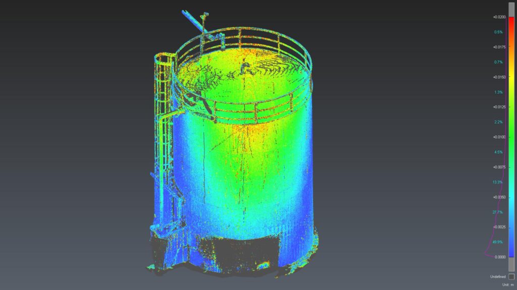
- A heat-mapped point cloud illustrating structural movement
- Visual comparisons highlighting localised deformation trends
- A complete digital dataset for engineering review, maintenance planning, and legal or risk assessments
Project Outcome
The monitoring identified measurable movement in several structures, enabling the client to assess and mitigate stability risks early.
Heat-mapped visualisations provided clear, data-driven insight for engineers, reducing uncertainty and supporting confident decision-making.
The result was a precise and reliable digital record, a “snapshot in time” that can be revisited for ongoing assurance throughout the redevelopment process.
Testimonial
“The project delivered excellent results. The precision of the data, coupled with the detail of the point cloud models, gave the client valuable insights to inform both structural assessments and potential legal considerations. This outcome reinforced confidence in the chosen survey methodology and showcased the team’s expertise and commitment to technical excellence.”
Mike France – Project Manager
Key Benefits
- Over 600 million points captured per visit for complete coverage
- Zero disruption to ongoing operations
- Fast, safe, and repeatable monitoring
- Visual data supporting legal, technical, and engineering decisions
- Robust alignment and validation through Cyclone 3DR
Interested in how Scan-Based Monitoring could support your next project?
Get in touch with our HDS Project Manager, Michael France or connect with him on LinkedIn to start the conversation.