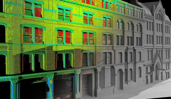
3D Laser Scanning Survey:
3D Laser Scanning or LIDAR (Light Detection and Ranging) is the process of shining a reflectorless laser line over a surface in order to collect 3-dimensional data. The surface data is captured by a camera sensor mounted in the laser scanner which records accurate dense 3D points in space. The 3D survey points collected combine together to form a point cloud that represent the surface surveyed.
Point clouds can be viewed in multi hue colours (based on signal intensity return) or true colour from a digital camera. This technique provides a solution for the rapid surveying of inaccessible surfaces or complex geometrical details. The data can be linked in 3D to your site grid and matched seamlessly with topographical survey plans, elevations and sections.
Laser scanning covers a number of techniques:
Close range: Sub ‘mm’ small objects or highly detailed surfaces observed from less than 0.5m away
Terrestrial: Ranges from 20m to 2km depending on the equipment, accuracy from 3mm to 100mm
Airborne: Usually helicopter based covering large areas to a lesser accuracy.
We utilise time of flight (Leica HDS ) and kinematic (helical) trolley based (Amberg) and mobile mapping scanners to allow our surveyors to find the best, most productive solution to a given survey problem.
What are the benefits of scanning ?
Laser surveying helps avoid assumptions, generalisations, errors in interpretation, problems by having the original data set to refer back to.
Cost Savings:
- Avoiding potential site revisits for missed data (office base field checking)
- Fast turnaround where access time is restricted (e.g. railway possessions, contaminated areas, live motorways, etc)
- High accuracy plans for retro fitting design work, avoiding on-site alterations and clashes
- A reduction in re-work and ‘fit-up’ problems
- The ability to amend the scope of projects without requiring a return to site
- Avoiding the need for access platforms as the survey is entirely reflectorless
- An archive record of the site at a snapshot in time which can always be accessed even though it may no longer exist in reality !
The benefits of working with laser scanning data are numerous and provide the advantage to multi-disciplinary teams; Architects, Civil Engineers, CAD Designers, Planners, Universities, Insurance Companies, Utility Sectors, Mechanical & Communicational Engineers the list goes on and is continually being added to.

What do I get as deliverables?
Laser scanning deliverables can be as simple or complicated as you require for any given project.
Some clients wish us to deliver the basic raw scan cloud data only. They can then archive the data for later use, use it for insurance purposes or use their in house CAD skills to extract line and point data from the cloud.
We can create data is a variety of geospatial formats such as E57, PTX, PTS, LAS, LAZ, Recap (RCP, RCS) and Leica specific Leica (LGS, cyclone).
Where internet speeds allow, we can also host point clouds on the web and allow data to be streamed direct to browsers to explore and measure from.